Thursday, August 22, 2019

Road Trip - The Last Leg...

When we left Holbrook this morning
we opted to take a different route home, and avoid Phoenix.
This route took us thru a couple of communities
that we had not visited before.


Hwy 77 South was literally straight as an arrow till we
arrived at Show Low/Pinetop-Lakeside AZ

Snowflake, was founded in 1878 by Erastus Snow
and William Jordan Flake, Mormon pioneers and colonizers. It
 has frequently been noted on lists of unusual place names.  
Pop 5564, elevation 5682’

A Side Note...
Snowflake, Arizona gets 11 inches of rain, on average, per year. 
The US average is 38 inches of rain per year. 
Snowflake averages 13 inches of snow per year. 
The US average is 28 inches of snow per year.  

Today it had a low of 60 and a high of 89… 
while Gold Canyon at elevation 1762’ 
had a low of 78 and a high of 106.  That's
why so many people from the Phoenix Valley
area "summer" in the White Mountains where
we were today.

While in Snowflake I took this photo of 
Andrew Rogers 1878 cabin which looked very 
inviting, don’t you think?

And boy did I get my pine tree fix for most of
this trip.

After touring neighboring communities of 
Show Low and Pinetop - Lakeside AZ
 we took Hwy 60 towards Gold Canyon…

The road went up for 800' - 1000' and then down,
(for another like amount), then up and down again, all
the while

it was zigging and zagging left and right as shown
on the navigation system map.  

FINALLY we ended up at the Salt River Rest Area

where this beautiful bridge crossed the river and then headed
up the other side, following similar elevation gains
and zigging & zagging!!!

AHHH, a normal looking road as we headed west towards
Superior, where

we had a fabulous Burrito before heading the
last 25 miles to

Home Sweet Home.

The Rest of the Story…

We were on the road for  nine days for a total
 of 1587.4 miles with an average mpg of 31.5 in our
 3 month old Honda CR-V “Touring” model.  
It was rated 33 mpg highway and our best was 34.1
and as you can tell these were not "highway miles" 
most of the time.

Weather was good to us, some wind & partly cloudy skies…
 (always welcome) and about 127 raindrops.

We learned more than we can ever remember, 
that’s why I took so many photos/videos. 

Next on the agenda hours and hours of editing all
 that video footage…  about 870 clips averaging 10-14 seconds 
per clip which means I have about 3 /12 hours of video 
to look at, select the part of the clip (usually 3-5 seconds) that
 I want, add titles, effects, music, etc., and review the
 whole edited mess  3 or 4 times before I’m happy.
  I estimate a finished video about 50-60 minutes long.
As you can see, a lot hits the cutting room floor!!!  
Now you know how I’ll be spending the 
rest of these hot summer days…
We hope you enjoyed the ride, and yes Don did
all of the driving.


Wednesday, August 21, 2019

Dam, Goose and Goose Chase


Day 8 of our Road Trip started in Dolores CO with a
visit to the Rio Grande RR Museum not only to learn
more about The Galloping Goose, which replaced the
more costly steam-powered passenger trains, but
to find a geocache... mission 
accomplished.

McPhee Reservoir's Dam creates a saddle on the
Dolores San Juan Divide.  It has a total capacity
of 381,195 acre  feet and has many "arms"...

with about 50 miles of shoreline.  It was a
beautiful sight and a warm day and I missed my California
kayaking buddies - Julie, Margie, Cathy and Mary Ann.
This picture's for you!!!
Since we were headed for Holbrook AZ today,
we decided we'd stop and look at anything that sounded
interesting on those roadsigns that point this way and
that to points of interest.  So this was the Goose Chase...
driving many miles to end up finding something we
didn't want to see!!!  Don't get me wrong but it is a
research facility and not set up for visitors unless you
schedule a tour ahead of time.
Even though we saw Shiprock Rock about 40 years ago, who
wouldn't want to see a monadnock rising nearly
1,583' above the high-desert plain of the Navajo Nation
in San Juan County, NM again and again?

Tomorrow will be the last day of this road trip as we head south
to discover new sites on our way home to Gold Canyon AZ


Ancient Archaeological Sites


This map gives you an idea of the size of area.
Our first visit was to Edge of the Cedars State Park
in Blanding UT - one of the finest we've ever visited.

This site sat on a knoll overlooking the valley below.

One of our favorite reconstructed objects was this
unique sun-dial.  It was quite complicated and I
intend do do more reading on how it not only helped
tell the time of the day but the days, months and year.

The entire large museum was fabulous, but one of the
most unique exhibits we have ever seen was the
incredible pottery collection that was stored on many glass
shelves for you to view.   Or you could use the computer,
click on an icon for any piece and it would be displayed
full size on the computer screen outside the exhibit area.

When we arrived in Dolores CO it was time to
stop by the Canyons of the Ancients National Monument
Museum & Visitor Center.
 
This museum had a different layout but covered many
of the same things as the prior Museum.
Don was impressed by the the exacting and artistic
brickwork in the welcoming courtyard...
and we spent a couple of hours inside viewing
hundreds of items in beautiful display cases.


One item in the "hunting" display tickled our funny bone.
 "Rabbit Sticks" were used to slay lightening fast
bunnies.  No you did not have to hit them over the head.
The tool is similar to a boomerang, except it doesn't
return to you.  To a skilled hunter that didn't matter
because he had to walk to retrieve the rabbit anyway!!!
 

Monday, August 19, 2019

Four Corners

The Four Corners Monument marks the quadripoint in the 
 ArizonaColorad New Mexico, and Utah meet.
 It is the only point in the United States
 shared by four states.


Don gets credit for 4 geocaches...

as he takes a knee.

and Nancy does a spread eagle!!!  Each state
is represented below:

Colorado

Utah

New Mexico

Arizona


The scenery coming and going
and crossing 4 state lines in a short time was
fun again.  Yes, this was a revisit.
 
And drilling for oil is alive and well in this area.
As you may have noticed, after some rather long
tirads, the blog entries are getting shorter and
shorter, and that is because I have been 
spending more time at the computer than
enjoying the sites.  So hopefully
things will get shorter and sweater!!!  Hugs...


Necks & Hats

Goosenecks State Park in Utah is one of the
most impressive examples of "entrenched river meander" on 
the North American continent.  While flowing a distance
of over six miles, it only advances 1.5 miles west towards
Lake Powell.

It's day 5 of our Road Trip -  Aug 18th.


The meandering canyon carved by the San Juan River
is 1,000 feet below this overlook.
 

The desert landscape reveals its underlying structure
 exposing 300 million years of geologic activity.

Even tho Don wanted to go to find a geocache,
which he did find, I liked this photo better than an
Amo can behind the sagebrush appropriately named
"Utah Geo Tour-San Juan - Goosenecks State Park".

On the way to the community of Mexican Hat,

we take a side trip for a closer look.  

OMG the community of Mexican Hat has
a new bridge...
The older one crossed the San Juan River a little
farther downstream.


Can Old be New?


As we continued our Road Trip we were revisiting places
we've seen in the past and looking for new sites to see.
Although the site may be 25,000 years old, if we haven't
seen it, it's new to us... so sometimes old is new...

Here's where we traveled on Day 4 - Aug 17th a new day...


Stop #1 the Petrified Forest - where we got acquainted with the
Giant Logs.  These trees died 216 million years ago and 
then took many years to become petrified.

The Park Ranger, told us that most of these trees were
conifers ferns and ginko.  Remember that 225 million years
ago, during the Triassic Period, this was a tropical landscape. 

We stopped at every site within the park and
walked most of the trails.
Age and/or mineral content gave everything
it's one unique color.

Some of these trees had reached at least 200 feet in height.
They grew tall with not many side branches except at
the upper crown point.

Hard to imagine the number of pieces of
petrified trees just lying around.

Who cut the logs?    It is possible with the uplifting of the
Colorado Plateau (starting over 60 million years ago),
the still buried petrified trees were under so much stress
they broke like glass rods.  The crystalline nature of the quartz
created clean fractures

Stop #2 The Painted Desert was exactly that... painted.
There were 5 of these "Teepees" but I zoomed in tight on this one

so you could have an up-close & personal experience.
 Don pulled over to look for a geocache and there we
 learned that the only place where the famous Route 66
crosses into a National Monument is here in the Painted Desert.
Yes, he found it...

The design for the glass ceiling in part of the restored
Painted Desert Inn came from pottery shards at Mesa Verde.  They
were hand painted on glass by the Civilian Conservation Corp (CCC).
The Painted Desert Inn is a National Historic Landmark.
Don also found a geocache here, where we also found ice cream...
which has become our lunch staple!!!!

This is just one example of the many photos
I took while stopping at a multitude of vista points
in the Painted Desert.  They go on for miles.

Stop #3 was Nancy's type of "geocaching stop".
It is located in Ganado AZ on the Navajo Nation
Reservation.  We stopped here about in about  1975

because I had studied Navajo and Tapestry
weaving and was in the process of writing a book
on Tapestry weaving.

.
John Lorenzo Hubbell purchased the trading post in 1878, ten years after
Navajos were allowed to return to their homeland from their
 terrible exile at Bosque Redondo, Ft. Sumner, NM. 
Hubbell family members operated this trading post until it was sold
 to the National Park Service in 1967. The trading post is still active, 
and operated by the non-profit organization,


And for a weaver it is pure heaven to walk into a
showroom stacked with piles of Navajo Rugs.
Back in 1975, I sat and watched a Navajo weaver
work on her rug on her traditional Navajo style loom
like this.  Navajo's teach by showing and not telling,
so I sat there on the floor next to her, patiently watching her do
a technique I was not familiar, without saying a word, as
unbelievable as that may sound.  She got up and went to
lunch... but I waited in our camper until she returned
so I could watch her finish the process she started before lunch...

and I included it in my book.

After  returning home from that trip, all those years ago,
I built a Navajo style loom and wove this rug in the
"First Phase Chief's Blanket" style, which consists of stripes
in red, white, blue & black.
On to our final stop of the day Stop #4


Pretty old...

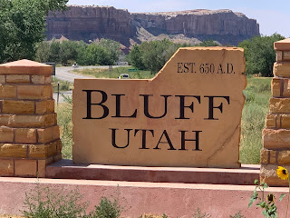
This is why it got it's name...surrounded by Bluffs.
and our great room at La Posada Pintada... 

where Don and I enjoyed enjoyed the view (about 600 feet away)
 while having cocktails on our back patio  - AHHHHH


Another Mixed Bag: Ruby + Flowers and other things...

Can you believe this weather for the Sacramento CA area in late JUNE???  Time to head outside. There were interesting vapor trails in a beau...